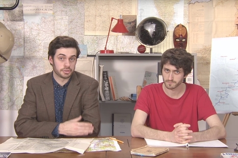

Mark Cooper-Jones and Jay Foreman, the Map Men, tap into a rich vein of geographical quirks to teach through comedy
Get Started for FREE
Sign up with Facebook Sign up with X
I don't have a Facebook or a X account


 Your new post is loading...
 Your new post is loading...
Your new post is loading...
Mark Cooper-Jones and Jay Foreman, the Map Men, tap into a rich vein of geographical quirks to teach through comedy 

Jeremy Hansen's curator insight,
August 29, 2016 12:43 PM
Holy heck these guys are good! I'd like to see more of these Map Men videos. I'm sure at least some of my 8th graders can appreciate some British wit.

Colleen Blankenship's curator insight,
January 22, 2018 1:21 PM
Funny and full of information!

Laurie Ruggiero's curator insight,
May 29, 2018 5:29 PM
Unit 1
Sign up to comment
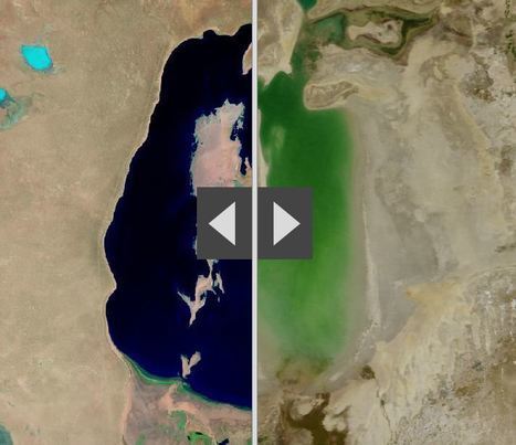
"By moving the slider, the user can compare 1990 false-color Landsat views (left) with recent true-color imagery (right). Humans are increasingly transforming Earth’s surface—through direct activities such as farming, mining, and building, and indirectly by altering its climate."

James Piccolino's curator insight,
March 24, 2018 9:46 AM
Wow. This is depressing. I knew of the Aral sea thanks to class, but the others I had no idea. They were so green and lush way back in the day. Now they are dead and seriously in a sad state. There is nothing wrong with development and advancement, but this is just a lot when it comes to impact.

othni lindor's curator insight,
October 20, 2018 4:01 AM
This map shows how human activities like farming has shaped the Earth's surface. The example they show is the Aral Sea. It is a
regional environmental problem. It is located between the Southern part of Kazakhstan and Northern Uzbekistan. It used to be the world's fourth largest saline lake. Human activities have caused the lake to be almost completely dried up. Over the years, the Aral Sea became polluted with pesticides and chemicals. 
Stevie-Rae Wood's curator insight,
October 28, 2018 9:51 PM
The Aral Sea is a severe environmental issue in Central Asia. This map that we are looking at shows how human activities such as farming have destroyed a natural wonder. The Aral Sea USED to be the fourth largest saline lake but has dried up. The Aral Sea has five times less volume and is five times more saltier than it once was. This occurred because people surrounding the area used more water and used it more intensely. The soviets thought it would be a good idea to use more water projects such as planting cotton, and rice which are water intense crops. This severely dried up the Sea. The area that the sea once was that is now dry land in uninhabitable because of the levels of salt left behind. As well the rivers that connected to the Aral Sea have either dried out or are on the verge of drying out causing many economic problems for those that depended on that water.
To understand today's global conflicts, forget economics and technology and take a hard look at a map, writes Robert D. Kaplan.
This is a timely article that shows the importance of geography in understanding current events throughout the world. Also included in this link are videos and pictures connected to an interactive map that highlights a few global conflicts. Students would benefit from reading this article in preparation for completing a news article assignment. Geographic context always matters; it might not tell the whole story but it will certainly shape it.
Tags: Geography, GeographyEducation, Unit 1 GeoPrinciples.

Wyatt Fratnz's curator insight,
March 19, 2015 10:05 PM
This informative article gives us a different insight to politics, claiming that countries action in politics, war, etc. are based upon where they are located. It goes on to describe different examples containing spatial, economic and political conflict. Afterward, it describes what this has to do and how it effects people (and their governments).
This gives us a great insight on how space is afflicted with the territorial dimensions of politics. It relates to why certain nations make the different decisions they do and how it is related to our everyday lives.
If you aren't using Google Earth... YOU SHOULD BE!
Amazing things about Google Earth - news, features, tips, technology, and applications...
If you've never seen the Google Earth Blog, this post is a good primer to the educational possibilities that this technology opens up to teachers. It is not just for geography teachers; it can be a visualization tool for any subject that has real-world applications that take place somewhere.
|
NASA's animation of China's Three Gorges Dam construction over the years.

Benjamin Jackson's curator insight,
November 9, 2015 5:40 PM
The impact of the Three Gorges Dam on the residents upstream is amazing. I cannot imagine anything like this happening in the US, mostly because of the impact on the people both upstream and downstream. Ecological damage from this dam may not phase the Chinese government, but I think any North American or European government would shudder at the thought of the backlash among their citizens this would create. 
Matt Ramsdell's curator insight,
December 14, 2015 9:27 PM
Three Gorges damn in China is the largest dam ever constructed. This was created to save on power by creating hydroelectric power for the people of the land. One of the issues with this was the the flooding of the land up streams displacing millions of people. It created a larger up stream area and very small down stream. A lot of the people that lived up stream had to be relocated further inland and faced changing climatif weather. The banks of the river are carved out between what seems like mountainous regions so as you move more uphill the weather and temperature will be a whole new category of life (Depending on how far you relocated).
Stevie-Rae Wood's curator insight,
December 9, 2018 6:09 PM
From the animation that NASA has created of the construction of the Three Gorges Dam it is apparent that land has been lost. The Three Gorges Dam was created to generate more energy for Chinas growing economy. It is known as the largest hydroelectric project ever costing around 40 billion dollars and requiring 20,000 workers. There is a good and bad side to the creation of this dam. It has helped Chinas economy grow however to the expense of the people that were displaced because the dam took away land as we can see In the animation. It also effected people downstream negatively as we can see as well because there water supply was depleted. Like most things that take place today the people that benefit from something usually live far away from the problem while those that live closest pay the more costly price.
Satellites have been watching us for 40 years. Here's what their images reveal.

Ambre Cooper's curator insight,
June 25, 2015 4:04 PM
This is a cool little video. It even shows the level of Aral Sea we read about. 
Hamdou Wane's curator insight,
June 29, 2015 7:55 AM
Satellites have been watching us for 40 years. Here's what their images reveal 
Alex Smiga's curator insight,
August 6, 2017 8:45 AM
Seth Dixon's insight:
This video is simple entry point into the various applications of remote sensing as well as various human and environmental interactions. This video highlights 5 examples: 1. Deforestation (Brazil) 2. Water Use (Aral Sea) 3. Urban Sprawl (Las Vegas) 4. Energy (Coal in Wyoming) 5. Climate Change (Ice Shelf in Antarctica)
This is really neat...a different way to give perspective !
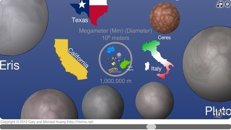
"Zoom from the edge of the universe to the quantum foam of spacetime and learn about everything in between."
Click "Start," and then use the slider across the bottom, or the wheel on your mouse, to zoom in -- and in and in and in... or out and out and out... It will take you from the very smallest features postulated by scientists (the strings in string theory) to the very largest (the observable universe). This really is a fabulous visual demonstration of scale at micro and macro levels. This is an excellent way to bring spatial thinking into the math curriculum as well.
Tags: Scale, perspective, space, spatial, Unit 1 GeoPrinciples.

Joe Andrade's curator insight,
July 7, 2013 10:08 PM
This is a great method of teaching some of the principals behind understanding spatial analysis. An important skill in understanding the world we live in.
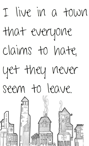
Make it real!
"Using the vocabulary of this course, please describe in detail the geographic context of a town like this (real or imaginary). What is the town like? How did it get that way? What type of meaning does 'place' have for those that live there? "
|